Showing 52 items matching road making construction
-
 Kew Historical Society Inc
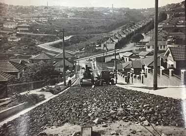
Photograph, City of Kew, Public Works, Road Construction, c. 1920s
... road making construction... department) road making construction City of Kew ...An original photograph donated to the Kew Historical Society by the City's Engineering Department before the amalgamation of Kew into the City of Boroondara in 1994. While not all of the photographs are of Studley Park, Kew or East Kew, each photo provides a fine snapshot of the work of local government engineering departments of the period. They reveal they types of labour conducted, the techniques used and the equipment and machinery in the possession of the local government authority. Public works. A photograph of a suburban street under construction using a steamroller. The street was photographed to demonstrate the issues relating to grading. Neither the street nor the location has been identified. Inscription on reverse: "The construction of a roadway in a 1 in 3 1/2 grade. / The waggon is hauling the roller, by means of a cable attached to a pulley anchored at the top of the grade." engineering, city of kew (engineering department), road making construction -
 Geelong RSL Sub Branch
History of Colin Quin, Late 20th Century
Colin Quin was a National Serviceman in the 1958 intake upon completion of National Service Colin Quin joined the Regular Army. Colin served with the 21st Construction Engineers the unit went to Wewak, Borneo. After Military Service Colin worked as a refrigeration mechanic and has the interesting hobby of making model aeorplanes from beer cans. Colin Quin is also a distant relative to Ned Kelly.This is the original story of Colin Quin.A detailed A4 paper discription of Colin Quin a National Serviceman in 1958 and commenced training in the 20 National Service Battalion. Colin Quinn and joined the Regular Army after completion of National Service. -
 Greensborough Historical Society
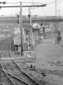
Photograph - Digital Image, Upgrades to Greensborough Station 1970, 1970_
Photograph of construction of the new station at Greensborough. The existing track can be seen plus construction of a second track, making the station an island platform. The new station was opened on 03/04/1970.Digital copy of black and white photograph. trains, greensborough railway station -
 Marysville & District Historical Society
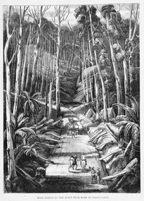
Work on paper (item) - Print of wood engraving, Ebenezer and David Syme, Road Making on the Black Spur, Road to Wood's Point, 1867
A copy of an early wood engraving of the construction of the road over the Black Spur in Victoria.A copy of an early wood engraving of the construction of the road over the Black Spur in Victoria. The Black Spur is known to be one of Victoria's most scenic drives. The road winds through a majestic forest of trees and tree ferns from Healesville to Narbethong and is part of the Maroondah Highway.black spur, wood's point, narbethong, maroondah highway, victoria, wood engraving -
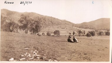
 Kiewa Valley Historical Society
Black and White photograph of Road Making Machinery, Kiewa Road Making, 25/08/1938
Construction of the main road from South Tawonga to the Bogong High Plains, to provide access to the construction sites for the new Kiewa Hydro Electric Scheme, was commenced early in 1938, the work being undertaken on behalf of the Commission by the Country Roads Board. For the construction work, the Commission purchased three Caterpillar - model R07 - diesel crawler tractors equipped with Kay Brunerei (Brunner) hydraulically operated trailbuilders (angle dozers). This acquisition resulted from a visit to the United States of America in May, 1937 by the Construction Engineer ( Mr. C.H. Kernot) and Assistant Civil Engineer (Mr. J.F. Douglas) where they saw this relatively new type of equipment in use. With the co-operation of the CRB, the Commission demonstrated the operation of these machines at Fishermen's Bend on 6th April, 1938. They were then sent to Kiewa where they commenced operation towards the end of the month. From South Tawonga, the route led immediately across the Western Branch of the Kiewa River necessitating the construction of a bridge 100 feet long. By the end of 1939, the excavation had been 'opened up' for a distance of 19 1/2 miles (approx. 31 km) and of this length, 10 miles (approx. 16 km) had been surfaced.The purchase and use of this type of mechanical equipment in road making was a huge investment, as prior to this most of the work would have been done manually with the use of picks and shovels. Not only were many months of hard manual labour saved, but a very significant amount of time in providing access to the proposed work sites for the new Kiewa Hydro Scheme. This photo is an excellent reminder of how primitive the early machinery was compared to the present but also represents the forward thinking of the State Electricity Commissions engineers in purchasing such innovative equipment . A black and white photograph showing the type of machinery used for road making in the 1930's. It shows a grader being towed by a caterpillar tractor.On the top left hand corner of the photograph , hand written in black ink is the words 'Kiewa Road Making 25/8/1938'. On the right hand side of the photo has been stamped in blue the Number 1. It has been developed on Velox paper (marked on back of photo) with a gloss finish.road making, state electricity commission, caterpillar tractor, kiewa -
 Kiewa Valley Historical Society
Black and White photograph of Road Making Machinery, Kiewa Road Making 25/08/1938 No. 2, 25/08/1938
Construction of the main road from South Tawonga to the Bogong High Plains, to provide access to the construction sites for the new Kiewa Hydro Electric Scheme, was commenced early in 1938, the work being undertaken on behalf of the commission by the Country Roads Board. For the construction work, the Commission purchased three Caterpillar - model R07 - diesel crawler tractors equipped with Kay Brunerei (Brunner) hydraulically operated trailbuilders (angle dozers). This acquisition resulted from a visit to the United States of America in May, 1937 by the Construction Engineer ( Mr. C.H. Kernot) and Assistant Civil Engineer ( Mr. J.F. Douglas) where they saw this relatively new type of equipment in use. With the co-operation of the CRB, the Commission demonstrated the operation of these machines at Fishermen's Bend on 6th April, 1938. They were then sent to Kiewa where they commenced operation towards the end of the month. From South Tawonga, the route let immediately across the Western Branch of the Kiewa River necessitating the construction of a bridge 100 feet long. By the end of 1939, the excavation had been 'opened up' for a distance of 19 1/2 miles (approx. 31 km.) and of this length, 10 miles (approx. 16 km.) had been surfaced. (see KVHS 0328)The purchase of this type of mechanical equipment in road making was a huge investment, as prior to this most of the work would have been done manually with the use of picks and shovels. Not only were many months of hard manual labour saved, but a very significant amount of time in providing access to the proposed work sites for the new Kiewa Hydro Scheme. This photo is an excellent reminder of how primitive the early machinery was compared to the present but also represents the forward thinking of the State Electricity Commissions engineers in purchasing such innovative equipment.A black and white photograph of road making near Mt. Beauty in 1938. Mount Beauty hills can be seen in the background with cleared land for grazing in the fore ground.Hand printed in black ink at the top of the photograph is 'Kiewa Road Making 25/8/1938'. On the right hand corner has been printed the number 2. It has been printed on gloss Velox paper.road making, state electricity commission, caterpillar tractor, kiewa, secv -
 Kiewa Valley Historical Society
Black and White photograph of Road Making Machinery, Kiewa Road Making 25/8/1938(No. 3 in a series of 8), 25/08/1938
Construction of the main road from South Tawonga to the Bogong High Plains, to provide access to the construction sites for the new Kiewa Hydro Electric Scheme, was commenced early in 1938, the work being undertaken on behalf of the Commission by the Country Roads Board. For the construction work, the Commission purchased three Caterpillar - model R07 - diesel crawler tractors equipped with Kay Brunerei (Brunner) hydraulically operated trail builders (angle dozers)). This acquisition resulted from a visit to the United States of America in May, 1937 by the Construction Engineer ( Mr. C.H. Kernot) and Assistant Civil Engineer (Mr. J.F. Douglas) where they saw this relatively new type of equipment in use. With the co-operation of the CRB, the Commission demonstrated the operation of these machines at Fishermen's Bend on 6th April, 1938. They were then sent to Kiewa where they commenced operation towards the end of the month. From South Tawonga, the route led immediately across the Western Branch of the Kiewa River necessitating the construction of a bridge 100 feet long. By the end of 1939,the excavation had been 'opened up' for a distance of 19 1/2 miles (approx. 31 km.) and of this length, 10 miles (approx. 16 km) had been surfaced.The purchase and use of this type of mechanical equipment in road making was a huge investment, as prior to this most of the work would have been done manually with the use of picks and shovels. Not only were many months of hard manual labour saved, but a very significant amount of time in providing access to the proposed work sites for the new Kiewa Hydro Scheme. This photo is an excellent reminder of how primitive the early machinery was compared to the present but also represents the forward thinking of the State Electricity Commission's Engineers in purchasing such new and innovative equipment.A black and white photograph of a Caterpillar diesel crawler tractor and a hydraulically operated trailbuilder (angle dozer) making a road in the Mt. Beauty area.Hand written in black ink in the top left hand corner are the words "Kiewa Road Making 25/8/1938". On the upper right hand of the photograph has been stamped the number 3. On the back is stamped the word 'Velox' severaly times, which is the make of the photograhic paper. roadmaking, caterpillar tractor, kiewa, state electricity commission -
 Kiewa Valley Historical Society
Black and white photograph of farmland, Kiewa, 25/8/38, circa 1938
This photograph was taken in August, 1938 at the time of road making in the area and some eight years prior to the establishment of Mt. Beauty township. The area was still being used for grazing, and the land was eventually acquired from the local land owners by the State Electricity Commission. The construction of the road, from Tawonga to the High Plains, was commenced in April of this year. This allowed men and heavy equipment to be transported to the work sites for the construction of the Kiewa Hydro Electric Scheme. An important photograph as it shows the upper Kiewa Valley as it was before the establishment of the town of Mt. Beauty. The land had been cleared of natural growth and has been used for grazing cattle. By 1946 housing construction had commenced for the new town of Mt. Beauty and by 1948 street construction in the southern part of the town was completed as far as Hill Street.A black and white photograph taken in the upper Kiewa Valley showing farmland with a group of three unidentified people sitting on the grass.Handwritten in black ink is the inscription 'Kiewa 25/8/1938'. In the right corner of the photograph has been stamped the number 6. On the back in a circle, some 14mm across, are the words 'Kodak Print'. The word Velox is also printed on the back.kiewa, mt. beauty, construction, grazing, secv -
 Kiewa Valley Historical Society
Postcard Circa 1950, Road to Bogong High Plains Kiewa Hydro Electric Project, Circa 1950's
This postcard was produced in the 1950's for the tourist trade in the Kiewa Valley and Alpine region. It encompasses the period when the State of Victoria was pressured by the ever increasing demand by industry and its population for electricity supplies. Hydro electricity was seen as an untapped natural resource to quench this demand. The Victorian Alps and the rivers flowing into its valleys was ideal for the construction of the Kiewa Hydro Electricity Scheme. The late 1940's saw the development of this scheme and the changing of sections of alpine landscape is covered by this and other postcards/pictures (tourists, construction workers, and established rural populations). This period in time was before the established wildlife and forest/nature groups became political activist who changed legislative acts to protect the environment.This rural region (Kiewa Valley/alpine plains) was at most only significant to a smaller group of winter sports, summer hikers/horse riders and rural farmers/graziers. The numbers of tourists and the increase in the local resident population was boosted by the construction of the Hydro Electricity Scheme. This influx to the regional population resulted in a corresponding diversity in services and brought about an environment that responded to a growing level of tourists and thereby permitting this industry to grow more rapidly than it would have naturally. This postcard details an attraction to the "cleaner" method of providing electricity. This postcard was purchased in 1950 by a surveyor at Landford's Gap.This black and white photograph on a Valentine's postcard is from a V2 Argus photograph.. It is on a 200g/m paper density photo side gloss. See 0480 (A) - (G) for other photos of similar postcards.In white lettering " ROAD TO BOGONG HIGH PLAINS KIEWA HYDRO-ELECTRIC PROJECT", V3secv, road making, victorian alps -
 Kiewa Valley Historical Society
Photo: Making of Kiewa Valley Highway at Tawonga
The Kiewa Valley Highway was/is a major road along the Kiewa River ending at Mt Beauty the site of the S.E.C.V. town built for the construction of the K.H.E.S.Black and white photo with roofless old car beside two horses pulling a cart with man behind the cart. All coming towards the photographer on a road with paddocks on each side.kiewa valley highway, road building -
 Ringwood and District Historical Society
Photograph, Subway construction at Warrandyte Road, Ringwood 1923. Taken from Pitt St
Typed below photograph, "Making Warrandyte Rd. subway 1923. Taken from Pitt St." -
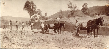 The Beechworth Burke Museum
Photograph, Late 1800s
This photograph depicts six men and two horses with carts in the process of constructing a road. The men each stand in a relatively relaxed position, posing for the camera. However, the amount of upturned soil surrounding them suggests the hard work they have endured, armed only with pitchforks and shovels. The creation of new roads in the Beechworth area had become a priority for the Beechworth council in the second half of the nineteenth century. This included connecting roads which radiated out of Beechworth to surrounding towns. This led to the expansion of the local government authority over the surrounding countryside, greatly strengthening Beechworth's central position. The use of horse and cart to take away the removed soil, as well as the style of the men's attire, suggests that this photograph dates back to the late 1800s. It can also be assumed that this photograph was taken somewhere in the surrounding hills of Beechworth. This photograph is historically significant as it provides insight into the rapid expansion of roads in and around Beechworth during the second half of the nineteenth century. Sepia rectangular photograph on matte photographic paper mounted on card Reverse: BMM 2982 / road construction, beechworth roads, 1800s, 1800s beechworth, beechworth hills, horse and cart, beechworth road making, beechworth council roads, road expansion, beechworth surrounding hills -
 The Beechworth Burke Museum
Geological specimen - Feldspathic Sandstone
Feldspathic arenites are sandstones that contain less than 90% quartz, and more feldspar than unstable lithic fragments, and minor accessory minerals.Feldspathic sandstones are commonly immature or sub-mature.These sandstones occur in association with cratonic or stable shelf settings. Feldspathic sandstones are derived from granitic-type, primary crystalline, rocks. If the sandstone is dominantly plagioclase, then it is igneous in origin Sandstone features prominently in public buildings throughout Victoria. Most of the sandstone used as dimension stone in the State came from three sources: the Heatherlie quarry in the Grampians (Silurian), the Bacchus Marsh area (Permian), and the Barrabool Hills near Geelong (Cretaceous).Sandstone features prominently in public buildings throughout Victoria, making this specimen special as it shows the materials used by Victorian building companies. Sandstone can also be crushed, crushed stone is used in the construction of roadways and road structures such as bridges, and in buildings, both commercial and residential. This specimen is part of a larger collection of geological and mineral specimens collected from around Australia (and some parts of the world) and donated to the Burke Museum between 1868-1880. A large percentage of these specimens were collected in Victoria as part of the Geological Survey of Victoria that begun in 1852 (in response to the Gold Rush) to study and map the geology of Victoria. Collecting geological specimens was an important part of mapping and understanding the scientific makeup of the earth. Many of these specimens were sent to research and collecting organisations across Australia, including the Burke Museum, to educate and encourage further study. A feldspar-rich sandstone, a sandstone intermediate in composition between an arkosic sandstone and a quartz sandstone, containing 10% to 25% feldspar and less than 20% matrix material of clay, sericite, and chlorite. Feldspathic arenite containing less than 90 percent of the composition of quartz. Feldspar is the main composition. Feldspathic arenite may contain fragments of unstable rock, and a little amount of other minerals such as mica and heavy minerals. Some feldspathic arenite have pink or red color because of the presence of potassium feldspar or iron oxide. There are also colored light gray to white. These sandstones are usually medium to coarse grained and can contain a high percentage of granules with angular until subangular roundness. The content of the matrix can appear as the rest up to more than 15 percent, and sorting of grains can present as moderate to poorly sorted. Feldspathic sandstones are generally immature in textural maturity. Feldspathic arenite can not be judged from the structure of the sediment. Bedding can emerge from the laminate parallel to the crossbed. Fossils may appear in the layer deposited on the sea. Feldspathic arenites usually appear on the craton or the continental shelf, which can be associated with conglomerate, quartz lithic arenite, carbonate rock, or evaporites. This sandstone may also appear on the succession of sedimentary basins deposited on an unstable or deep sea, and moving arc setting. According to Pettijohn (1963) Arkose make up about 15 percent of all sandstones. Some Arkose formed in situ when the granite and related rocks disintegrate and generate granular sediments. Most of the material feldspathic sandstones derived from primary crystalline granitic rocks, such as granite or metasomatic rocks containing abundant potassium feldspar. Mineral contained in sandstones is mostly a form of plagioclase feldspar derived from quartz diorite or volcanic rock. Feldspar contained on this sandstone comes from arid to cool climates when the chemical weathering process is reduced.sandstone, natural stone, feldspathic sandstone, burke museum, geology, geological, geological specimen -
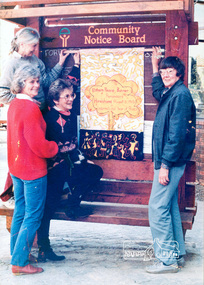 Eltham District Historical Society Inc
Photograph, Ron Grant, The Eltham Peace Group hanging the Hiroshima Day Banner on the Community Notice Board, Arthur Street, Eltham; Community Arts 1986 'As We Are' Banner Project Group, Hiroshima Day, 6 August 1986
Arthur Street, Eltham next to ANZ Bank The Hiroshima Day Banner was made by Jacky Talbot as part of the project. The women wanted to do something for Hiroshima Day and suggested that a workshop be set aside to make a banner. The artist was concerned about the remaining time scheduled for the project and spent several days "whipping" up the banner herself. For the artist this banner was to prove quite significant. The women hung it at the Community Notice Board on Hiroshima Day and were photographed by the local newspaper publicising the group and drawing wider community attention to the remembrance of the day. Although no new members joined the group from this activity, the artist felt that she was more fully accepted by the group afterwards. This banner has initiated a small group of women committed to peace. The artist has also continued to liaise and meet with the women as time permits. Future group plans include: making kimonos to wear when carrying the banner, participating in the Palm Sunday March, an observance of Hiroshima Day activity, which is yet to be decided, establishing contact with a sister-town in USA and USSR and supporting Eltham Council's stance as a Nuclear Free Zone. (The banner habits of the Eltham tribes : Eltham Shire "as we are" Community Banner Project report / by Jacky Talbot, Shire of Eltham, Feb. 1987, p46) Used in Shire of Eltham display at the Eltham Community Festival, 7 November 1987. Shire of Eltham Engineering Department Providing the resources to undertake • Survey, design, consultation • Road construction and maintenance • Bridge construction and maintenance • Street sweeping • Drain and pit cleaning • Traffic engineering installation and maintenance • Garbage collection • Tip management, land reclamation and beautification • Maintenance of community buildings • Provision of community and recreation facilitiesIllustrative of services provided by former Shire of ElthamColour photograph 20 x 29 cm mounted on green-painted chipboard 28 x 35.5 cm (string on back for hanging) Ref: 01842-0Title printed on label adhered to board below photograph (replaced June 2017)display panel, eltham festival, eltham peace banner, hiroshima day banner, infrastructure, shire of eltham, laurel eckersall, anne laurence, betty johnson, joan maclagan -
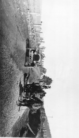
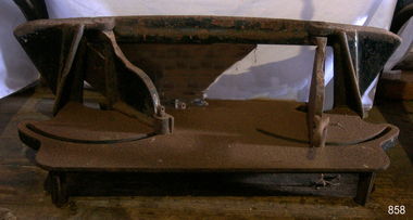
![No.2 [Steam] Roller, Kew City Council](https://victoriancollections.net.au/media/collectors/550653872162f11fb04854aa/items/5c31f69121ea670d8459a8b6/item-media/5c31f77a21ea670d845a8063/item-fit-380x285.jpg) Kew Historical Society Inc
Kew Historical Society IncPhotograph, No.2 [Steam] Roller, Kew City Council, c.1950
... of Kew in road construction from the 1930s to the 1950s. Reverse ...The Number 2 Steamroller was used in public road building in Kew.It replaced the first Council steamroller which was used between 1915 and 1932.Rare photograph of a Kew City Council piece of road making machinerySmall black and white photograph of a steamroller used by the City of Kew in road construction from the 1930s to the 1950s.Reverse of photo: "KCC No 2 Roller 607S". Accompanying note: "20/3/84 Gift to the Society from Mr [?] who was K.C.C. [Kew City Council] driver of this "monster". Kew City Council No.2 Roller. Used in street construction 1950. Roller probably 1930 era."road construction - kew (vic), no.2 steamroller, steamrollers - kew (vic) -
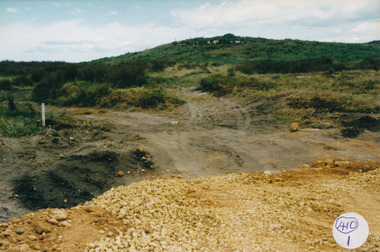 Port Fairy Historical Society Museum and Archives
Photograph
South Beach Development Coloured photograph of Large hill with track leading to the left during construction410/1 (since removed 2021)south beach, development, ocean drive, street making, roadmaking -
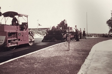
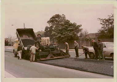 Kew Historical Society Inc
Photograph - Studley Park Road Reconstruction, 1968
One of a series of photographs donated by the City Engineer of the former City of Kew, relating to road works. The photos variably include council workers, signage and equipment.One of a series of photographs of core local government services as practised by the City of Kew. The photographs are an accurate record of street works of the period. This example is one of the few shot in colour in the 1960s. Original colour photographic positive of roadworks in Studley Park Road in the former City of Kew. A tip truck carrying bitumen unloads it contents on the road which is then levelled by a tray. Road workers supervise the road making. "STUDLEY PARK ROAD RECONSTRUCTION / 1 1/2" NOM [sic] SIZE BIT BINDER COURSE / JANUS CONSTRUCTIONS / 9TH OCT 1968"city of kew, local government -- city of kew, road works, street works, studley park road -- kew (vic.) -
 Kew Historical Society Inc
Photograph, City of Kew, Public Works, Road Construction, c.1920s
An original photograph donated to the Kew Historical Society by the City's Engineering Department before the amalgamation of Kew into the City of Boroondara in 1994.While not all of the photographs are of Studley Park, Kew or East Kew, each photo provides a fine snapshot of the work of local government engineering departments of the period. They reveal they types of labour conducted, the techniques used and the equipment and machinery in the possession of the local government authority. Public works. A photograph of a suburban street under construction using a steamroller. Neither the street nor the location has been identified. It is believed that the photograph can be dated to the 1920s. Inscription on reverse: "Road making. (?1920s cars)".steamroller, road construction building, city of kew, city of kew (engineering department) -
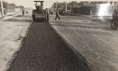
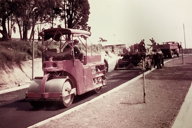
 Kew Historical Society Inc
Photograph, Public Works, Road Construction, 1950s
... Photograph Photograph Public Works, Road Construction Public works ...An original photograph donated to the Kew Historical Society by the City's Engineering Department before the amalgamation of Kew into the City of Boroondara in 1994.While not all of the photographs are of Studley Park, Kew or East Kew, each photo provides a fine snapshot of the work of local government engineering departments of the period. They reveal they types of labour conducted, the techniques used and the equipment and machinery in the possession of the local government authority. Public works. Road making in the 1950s using a steam roller and a mechanical grader. Inscription on reverse: "Road making." city of kew (engineering department), road construction building, road maintenance -
 Kew Historical Society Inc
Photograph, Public Works, Road Construction, 1950s
... Photograph Photograph Public Works, Road Construction Public works ...An original photograph donated to the Kew Historical Society by the City's Engineering Department before the amalgamation of Kew into the City of Boroondara in 1994.While not all of the photographs are of Studley Park, Kew or East Kew, each photo provides a fine snapshot of the work of local government engineering departments of the period. They reveal they types of labour conducted, the techniques used and the equipment and machinery in the possession of the local government authority.Public works. Road making in the 1950s using a steam roller and a mechanical grader. Inscription on reverse: "Road making." city of kew (engineering department), road construction -
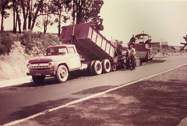 Kew Historical Society Inc
Photograph, Public Works, Road Construction, 1950s
An original photograph donated to the Kew Historical Society by the City's Engineering Department before the amalgamation of Kew into the City of Boroondara in 1994.While not all of the photographs are of Studley Park, Kew or East Kew, each photo provides a fine snapshot of the work of local government engineering departments of the period. They reveal they types of labour conducted, the techniques used and the equipment and machinery in the possession of the local government authority.Public works. Roadmaking machinery in the 1950s using a tip truck and other equipment. Inscription on reverse: "Road making. Date?" city of kew (engineering department), road construction maintenance -
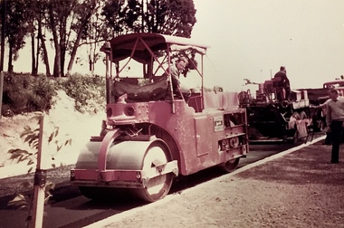 Kew Historical Society Inc
Photograph, Public Works, Road Construction, 1950s
An original photograph donated to the Kew Historical Society by the City's Engineering Department before the amalgamation of Kew into the City of Boroondara in 1994.While not all of the photographs are of Studley Park, Kew or East Kew, each photo provides a fine snapshot of the work of local government engineering departments of the period. They reveal they types of labour conducted, the techniques used and the equipment and machinery in the possession of the local government authority.Public works. Roadmaking in the 1950s using a steam roller. Inscription on reverse: "Road making. Date?" city of kew (engineering department), road construction building -
 Flagstaff Hill Maritime Museum and Village
Tool - Wood Mitre & Trimmer Guillotine, Early 20th century
The mitre trimmer is a classic hand-powered tool for picture framers and trim carpenters that has remained relatively unchanged for decades. It is heavy, simple, and sturdily built of cast iron with tempered steel guillotine blades. It is used for taking super accurate, paper-thin slices off the ends of mitres and butt joints, and leaving behind a glassy-smooth surface. Also used in picture frame making or cabinet woodworking, by placing a piece of timber in one side after setting the desired angle and pulling a handle that operates a guillotine blade thereby cutting the timber or decorative trim to the required angle.A significant tool still in use today in many cabinet makers workshops. The subject tool gives insight into how this type of tool development, design and use has not progressed since it’s original invention. It is still for sale from many tool manufacturing companies and use in small craftsmen boutique workshops today as it was many decades ago.Cast Iron wood Trimmer bench like construction on raised feet with 2 adjustable gates. Noneflagstaff hill, warrnambool, shipwrecked-coast, flagstaff-hill, flagstaff-hill-maritime-museum, maritime-museum, shipwreck-coast, flagstaff-hill-maritime-village, cabinet makers tools, picture framing, mitre cutting, wood trimming -
 Flagstaff Hill Maritime Museum and Village
Nail, circa 1810
This copper nail, sometimes known as a ‘Dumpy Bolt’ or spike, was salvaged from the hull of the wreck of the “George III”. It dates back to at least 1810. It was found by an abalone diver on the south east coast of Tasmania. The nail would have been used to hold the layers of the ship’s keel frame and the planking together. The nail has been passed from the abalone diver to an interested business man on a trip to the south of Hobart, on again to the business man’s close friend who then donated it to Flagstaff Hill Maritime Village. The metal of nails such as this one, after being in the sea for a long time, become affected by the natural reaction of the sea water, causing it to degenerate and thin, and the stress from the force of the sea over the years alters its shape. Iron nails had been used on ships previously, but they quickly corroded in the salt; ships needed regular, costly and time-consuming maintenance to replace the iron nails. Towards the end of the 18th century the British Navy trialled the use of copper nails, finding them to be very successful. Merchant ships began to adopt this process in the early 19th century, although it made ship building very expensive and was more often used for ships such as the “George III” that sailed on long voyages. The three masted sailing ship “George III” was a convict transport ship built in Deptford, England, in 1810. On 14th December 1834 she left Woolwich, England, bound for Hobart Town, Van Diemen’s Land (Tasmania), under Captain William Hall Moxey. She was carrying 220 male convicts plus crew, guards and their families, totalling 294 persons (another 2 were during the voyage). Amongst the cargo were military stores including several copper drums of gun powder. On 27th January 1835 the “George III” was near the Equator, about half way into her journey. A fire broke out and the gun powder was in danger of explosion, threatening the whole ship. Two convicts braved the heat and smoke, entered the store and seized the gun powder drums, suffering burns for their efforts but saving a probable disaster. The fire destroyed some of the provisions and food was scarce. Many became ill with scurvy and some died during the journey. Nearing the end of their journey on 10th April 1835 the “George III” was headed through the D'Entrecasteaux Channel, south east Tasmania, between the mainland and Bruny Island. She was sailing in the moonlit night to hasten her arrival in port due to the great number of sick on board. She struck uncharted rocks, known only to the local whalers, between Actaeon Reef and Southport Lagoon and within hours began to break up. The ship’s boats were used to first rescue the women and children. Firearms were used to help quell the panic of the convicts below decks and some were killed by the shots. Many convicts, including the sick, were drowned. In all, 133 lives were lost including 5 of the crew, guards and their families. It was the third worst shipping disaster in Tasmanian waters. A monument in honour of the prisoners who perished in the “George III” has been erected, noting the date of the wreck as “Friday 10th April 1835.” (NOTE: there are a few differences between sources regarding dates of the shipwreck, some saying March and others April 1835. There are also differences in the figures of those on board and the number of lives lost.) The copper nail is significant as an example of sailing ship construction; fasteners used in the early 19th century on ships carrying convicts to Australia. The nail is also significant for its association with the ship “George III”. The “George III” is registered on the Australian National Shipwreck Database, ID 7195 as an Historic Shipwreck. She is the third worst shipwreck in Tasmanian waters. She is also associated with Early Australian History and the transportation of convicts to Australia. The incident of the fire on board and the bravery of the convicts in making the gun powder safe is an example of the social character of the people in early Tasmanian colonisation. Copper nail (also called a Dumpy bolt or spike) from the convict ship George III, wrecked in 1835. Nail is long, bent in an ‘L’ shape about 3/5ths along, tapering from both ends to the bend. Both ends are flat and do not taper to a point, nor have a thread. The shorter end has been polished, showing bright copper. There is pitting along the nail and virdigris is evident on the longer, unpolished end. The nail is displayed with the longer section resting on a wooden board between two ‘U’ shaped uprights, the shorter section upright. flagstaff hill, warrnambool, shipwrecked coast, flagstaff hill maritime museum, maritime museum, shipwreck coast, flagstaff hill maritime village, great ocean road, george iii, ship construction, ship nail, 1835 shipwreck, 19th century shipwreck, william moxey, d'entrecasteaux channel, convict transportation, copper nail, dumpy bolt, spike, keel nail -
 Flagstaff Hill Maritime Museum and Village
Tool - Archimedes Drill, 1900 to 1930s
The Archimedes drill, also known as a fretwork drill, is an old type of drill which works on the Archimedian principle; the drill rotates quickly as the barrel on the stem is worked up and down. This tool provides a quick and easy way to bore holes through ordinary fret wood and other substances, smaller versions are used in jewellery making where precision drilling is required. There were numerous different sized Archimedes drills made from various materials, usually a combination of wood and steel, some being all steel and some including brass parts. The fancier versions of these drills included parts made from Rosewood, Ebony, Ivory and decorative brass parts. Some of the later Archimedes drills had technological improvements such as a ratchet device and the inclusion of fly-weights. The ratchet device allows the drill to revolve continuously in the cutting direction. The fly-weights give momentum to maintain the speed of the drill during the upward stroke of the hand. Most old examples have no makers names.A vintage drilling tool that has been nickel plated with brass fitting and easier to sterilise. The item therefore could have been used in the medical profession as a bone drill during surgery. Weighted Archimedes drill all metal construction, nickel plated with brass handles centrifugal typeNoneflagstaff hill, warrnambool, flagstaff-hill, flagstaff-hill-maritime-museum, maritime-museum, shipwreck-coast, flagstaff-hill-maritime-village, archimedean drill, drill, tool, drilling tool -
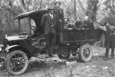 Halls Gap & Grampians Historical Society
Photograph - B/W, C 1930s
Photo shows construction workers involved with the making of Dunkeld/Grampians Road. One man is standing on the running board of a small truck, six men are seated or standing in the tray, another man is standing on the ground at the back of the vehicle.access routes, roads, people, road gang -
 Orbost & District Historical Society
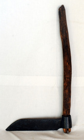
Paling knife, shingle froe, c. 1870s - 1930s
Likely used by the Jensen family who were early settlers in the Martin's Creek area, 35 miles north of Orbost, along the Bonang - Orbost Road in c. 1890. Peter Jensen came from Denmark. A flat iron blade, sharpened on the bottom and attached to a wooden handle. The blade has a pointed end.BRADES CO.shingle-making roofing-shingles house-construction -
 Eltham District Historical Society Inc
Document, Photocopy of receipts
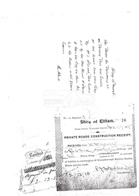
1. Private Roads Construction Receipt, Shire of Eltham for payment by W. McDonald on account of liability to construction of Greensborough Railway Station Estate private roads 2. Receipt for road making of Rattray Road, 13 March 1965Digital file only scanned by EDHS from item on loan (photocopy only)greensborough railway station estate, i. mcdonald, private roads, rattray road, receipt, road construction, w. mcdonald -
 Ballarat Tramway Museum
Photograph - Black & White Photograph/s - set of 4, early to mid 1973
Set of four Black and white photographs of some of the people, volunteer workers who were involved in the construction of the BTPS depot and trackwork - mid 1972 to 1973. .1 - Gavin Young in the mess room .2 - Richard Gilbert in the mess room .3 - Bill Kingsley, ?, ? Bounds and Gavin Young standing by an old tar heater being used as a heater in front of No. 1 road. .4 - Richard Gilbert, Andrew Hall, Bill Kingsley and Gavin Young - making up boxing for the cut off walls - early to mid 1973. See - 1972 - 1973 Annual Report which has a list of dates on page 3 of events at the depot.trams, tramways, depot fan, btps, construction, people and places, tram 14 -
 Whitehorse Historical Society Inc.
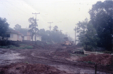
Photograph, Creek Road - road making, 1/06/1961 12:00:00 AM
Colour photo taken of a 33mm slide of the Creek road being constructed in June 1961 (Note first sign of brick veneer in street.)creek road mitcham, tresider, dot, road construction and maintenance